
To understand Henderson County and its people, it is essential to understand the geography.
Water is essential to survival. The rivers and streams determined where the people settled and farmed.
The people must raise food and animals for survival. The soil of a region determines the types of crops that can be grown. People must settle on land suitable for farming and with acreage for feeding and raising the farm animals. The animals and fish that are native to the region are important to the people’s meat source. The native plants and herbs are also used as food sources. These plants and herbs can also be used as medicines.
People must build some time of shelter. The geography determines the best places to build a home. The species of trees and types of rock determine what type of shelter will be built.
The climate, geography and wildlife determine what clothing is worn, the materials from which the clothing is made and the type of clothing that is needed.
The geography determines how the people heat their homes. What is available for fuel and how long will a heat source be needed?
The geography also determines the type of transportation suitable to the region.
Henderson County is located in the Blue Ridge Mountain Range of the Southern Appalachian Mountains. Our local people are Appalachian Mountain people.
Some of the mountains are escarpments – a steep slope or long cliff that occurs from erosion or faulting and separates two relatively level areas of differing elevations. The Blue Ridge Escarpment is where the Piedmont and mountains meet and it is partially located within Henderson County. People had to move in and out of the county through gaps between the mountains and escarpments.
North America’s largest granite fissure cave, Bat Cave, is located at the border of Henderson and Rutherford Counties. The trail leading to the cave is within Henderson County. The cave itself is “over the line” in Rutherford County.
The Bat Cave system is more than a mile long. Fissure caves are formed by movements of the earth – earthquakes and other shifts. The rock in Bat Cave is angen gneiss, a granite formed about 535 million years ago during the Cambrian period.
http://www.blueridgeheritage.com/attractions-destinations/bat-cave
The Eastern Continental Divide is within Henderson County. This is one of the most important geographical facts related to our history. This is the fact that many historians ignored and, therefore, missed its early historical significance. This is the ridge line of the Blue Ridge. It’s where the “easterly and westerly waters divide.”
There are six rivers within the county. Two rivers are west of the ridge line: French Broad and Mills River. Four rivers are east of the divide: Broad (Rocky Broad), Hungry, Pacolet (North Pacolet) and Green River.
Almost all books written on our county history ignore the rivers, mountains and settlements east of the ridge and the rivers east of the ridge.
Exploration, treaties with the Cherokee, formation of counties, and early settlement patterns as noted in land deeds were all based on the location of the rivers, streams, mountains and the Continental Divide.
There are at least two significant bogs or swamps within the county. There is a bog or wetlands in the East Flat Rock area. By far the largest bog or swamp is the land surrounding the town of Hendersonville.
The most rugged areas of the county are in the northwest section of the county (Pisgah Mountains), the northeast section (Hickory Nut Gorge and Blue Ridge Escarpment), and along the Green and Hungry rivers (Blue Ridge Escarpment). Many of the mountains in the county have narrow ridge tops and steep sides. Some of the mountains have perpendicular, bare rock walls such as the northwest side of Sugarloaf Mountain.
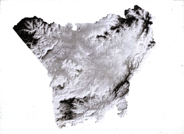
There is an intermountain plateau or valley of 75 to 80 square miles within the center of the county – Mills River, Hendersonville, Flat Rock, Edneyville, Etowah, Fletcher.
The largest flood plain is along the French Broad River and the Mills River, with surrounding tributaries (Cane Creek, Mud Creek, Clear Creek, Hoopers Creek). The bottom land is one mile wide in some places along this flood plain.
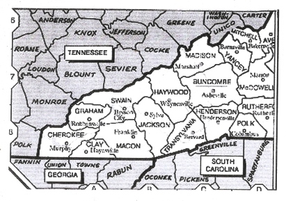
The county is surrounded today by the following counties: Rutherford, Buncombe, Haywood (at the northwest tip), Transylvania, Polk and Greenville County, S.C. It is impossible to study the history of Henderson County without some knowledge and understanding of the surrounding counties, along with county and state formations.
Despite stories and myths to the contrary, the rivers and many of the streams and mountains were named by early explorers from the 1600s and early 1700s. None of the rivers were named by William Mills. The myths and stories surrounding Mills are some of the most numerous and factually inaccurate of any in our county’s history.
The region of Henderson County was not an unknown, unexplored, unmapped region when the first settlers arrived in the 1780s. That is one of the worst, most glaring and inaccurate mistakes in our county’s history.
The French Broad and Mills (Mille) River (mille is French, many different meanings – thousand, nautical mile, mille mercies as thanks a million) are noted on the De Brahm map of 1766. The Broad (Rocky Broad) is noted on the Collet map of 1770. The Pacolet and Green rivers are noted on early 1700s maps in South Carolina.
The French Broad, with its headwaters in Transylvania County, flows through Henderson County into Buncombe County and through Western North Carolina into Tennessee, emptying into the Mississippi River. The Mills River is only within Henderson County and empties into the French Broad.
The Little Hungry River is the headwaters of the Hungry River. The Hungry River empties into the Green River.
The Green River has its headwaters in the Green River community, almost to the Transylvania County line, flows through Henderson County into Polk County, and empties into the Broad River in Polk County.
The Pacolet River (North Pacolet), with its headwaters above the manmade Lake Hosea in the Mountain Page community of Henderson County, flows into Polk County and to South Carolina, where it empties into the Broad River.
In Rutherford County there are several Broad Rivers that will eventually flow into the main Broad River. It can sometimes be difficult to distinguish which specific river is referenced on early land deeds.
The headwaters of the Main Broad River is in southeast Buncombe County. This river is often called the Rocky Broad as it flows through Henderson County and becomes the Main Broad River in Rutherford County. The river continues to Cleveland County and into South Carolina.
The First Broad River is in Rutherford County and is some times called the Sandy River on early maps. It flows into Cleveland County, where it flows into the Main Broad River.
The Second Broad River begins in McDowell County, flows into Rutherford County and continues to Cleveland County where it enters the Main Broad.
The Broad River with all its tributaries joins the Saluda River near Columbia, S.C., and empties into the Atlantic Ocean.
Click on the links below for more information on the geography of Henderson County.