
The Upward community was a “crossroads” in the early history of Henderson County. It is where the Howard Gap Road crosses “the Ridge.” This crossroads was traveled by American Indians and the early settlers.
Early settlers into the community began calling the community Crossroads, and sometimes Jones’ Crossroads.
In the late 1830s and early 1840s, John Parker V, a South Carolina plantation owner and husband of Emily Rutledge, purchased land in Henderson County for a summer home. Most of the land that he purchased is within today’s Tracy Grove community, but some of it extended into Crossroads.
Parker named his summer estate “Upward,” and the community began to be called Upward.
Upward is bordered to the north by the Dana community. The Tracy Grove community borders Upward to the north and west. East Flat Rock is to the west, and the community of Macedonia is to the south. Polk County borders the Upward community on the east.
Since the heart of the Upward community is crossed by the Eastern Continental Divide, all streams to the west of Upward Road flow into the Mississippi River and on to the Gulf of Mexico. All streams east of Upward Road flow into the Atlantic Ocean.
There are two rivers within the Upward community, the Hungry River and the Green River.
Near the area where Dana and Upward meet, the Little Hungry (headwaters of Hungry River) will join with other streams to form the Big Hungry River (Hungry River). This is near the Deep Gap area of the Upward/Dana section. The Big Hungry River then flows into the Green River.
This east section of the Upward community consists of some of the most rugged and steep land in Henderson County. This is the section of the community that borders Polk County, where the Piedmont meets the mountains. This was the site of the first water-driven dams and power houses to bring electricity into Henderson County.
Today, most of the land in Upward bordering the rivers is owned by the N.C. Wildlife Resources Commission as part of the Green River Game Lands.
The land west of the ridge, and land at the top of the ridge, is within the inter-mountain plateau. It is some of the best farmland within the county.
Trails and Roads
Today’s Upward Road that becomes Ridge Road in Dana follows the Eastern Continental Divide, the ridge line of the Blue Ridge. The Divide or Ridge in Upward begins near Crest Road, approximately where Blue Ridge Road and Crest Road meet, and then proceeds along Crest Road to Upward Road.
This was an ancient Indian path, called the Saluda Path. The ancient Indian trail connected several American Indian tribes from South Carolina to Virginia. Saluda Gap, between South Carolina and North Carolina, is located below the Green River community in South Carolina, in today’s Greenville, S.C., Watershed. It parallels old U.S. 25 through Green River, Tuxedo, Zirconia and Flat Rock. At Flat Rock the ancient Indian path then follows the crest of the Blue Ridge, the Eastern Continental Divide, into today’s East Flat Rock and on to Upward, where at the “crossroads” it intersected with another ancient Indian path that is known today as the Howard Gap Road.
This ancient Indian path (Howard Gap Road) begins in South Carolina near today’s Spartanburg, S.C., and proceeds into today’s Polk County. The trail enters Henderson County in the Macedonia community, crosses the Green River in Macedonia, directly underneath the interstate 26 bridge that crosses Green River today. The trail then proceeds in a steep ascent into the Upward community where it intersects with the ancient Saluda Path at the crossroads.
Early Deeds and Settlers
Crossing the Green River along this early path (Howard Gap) was extremely difficult in the late 1700s and early 1800s. The river was swift and near rapids, not an ideal crossing for those settlers moving into the mountains with heavily-laden wagons. The crossing was calmer and shallower at the old Mills Gap Road area into the Edneyville section of the county. And the ascent after crossing the Green River is one of the steepest in the county. One must also cross the Hungry River, with another extremely steep ascent.
Therefore, most of the earliest settlers first settled on land in the Dana and Edneyville communities, closer to the Mills Gap Road area.
These early settlers then began moving further out into the area that is today Upward. These were the same families who first settled in the Sugarloaf area of Edneyville and farther into Dana: Jones, Stepp, Case, Tabor, Justus, Blackwell, Justice, Duncan, Gibbs, Hill, Jackson, McCraw, McGraw, King, Gilbert and others.
Other settlers began moving into the area after Peter Guice built a bridge crossing Green River. Many of these families moved into Upward from the communities of Mountain Page and Macedonia . These were the Ward, Pace, Staton and other families. Some families, such as the Cagle family, will later move into the community from areas west of the community, in the Clear Creek section of the county.
East of the “ridge” was rough, mountain land. Families used the bottom lands near the rivers and creeks for farming, as they were self-sufficient Appalachian Mountain folk. They also raised large numbers of sheep on the slopes.
Along the ridge and west of the ridge, where the land was not as steep and rugged, there were larger farms. By the mid-20th century many of the farmers in this area were establishing apple orchards.
As late as the 1970s the area with motels, restaurants and convenience stores at the intersection of Interstate 26 and Upward Road was the site of one of the larger apple orchards in the county owned by J. Grady Hill, Appleland Orchard. Visit https://news.google.com/newspapers?nid=1665&dat=19731016&id=1T5PAAAAIBAJ&sjid=WyQEAAAAIBAJ&pg=6102,4009185&hl=en
There were also large asparagus fields along Upward Road near its intersection with Crest Road as late as the 1940s.
Based on the oldest graves in the community’s cemeteries, the Tabor family was one of the first families to settle in what is today Upward.
One of the earliest and largest land owners in Upward was Robert Jones, a son of John Jones Sr. who was one of the earliest settlers where the communities of Edneyville and Dana meet near Sugarloaf. Robert Jones owned land from the “crossroads” to Green River and into today’s Polk County.
Another of the early settlers and largest landowners in the community was John Justus Jr. He owned land from the “crossroads” to the Big Hungry River; and from the “crossroads” to Bats Fork Creek in what is today East Flat Rock. This includes the majority of land on the east side of Upward Road, and along both sides of today’s Crest Road. His brother, William Justus, owned the tract below John Justus Jr. to the Green River.
The King, Blackwell, Case, Pace, Stepp and Staton families also owned substantial amounts of land in the community. Prior to and after the Civil War, Jacob Cagle had a pottery kiln at the “crossroads.”
Early post offices
The first post office in the community was established in 1881. Prior to this time most of the residents would have received mail at the Blue Ridge Post Office in Dana. This first post office was the Baxter Post Office located in the area of Deep Gap near where the headwaters of the Big Hungry River, called the Little Hungry River by local folks, flows into the Big Hungry River. This is at the border of the Dana and Upward communities. Goven Tabor was the first postmaster, followed by Francis M. Blackwell. This post office closed in 1914.
The Upward Post Office opened in 1887 at the “crossroads” in a store in the community owned by Thomas Everette Waters. His son, Thomas Jefferson Waters, was the first postmaster. Later, Thomas Everette Waters became the postmaster when his son resigned. The post office closed in 1905.
In 1899, a post office named Decatur was established on the Big Hungry Road, across the river and not far from the Polk County line. Daniel Lafayette Morrison was the postmaster. This post office closed in 1906. This post office was in the log cabin built by Hiram King Jones, a son of Robert Jones, in the 1840s. A daughter, Emily Delilah Jones, had married Daniel L. Morrison and, after their marriage, they obtained ownership of this log cabin. After the death of Emily Jones Morrison, the cabin was owned by the Upward Community Club. The club moved the cabin to U.S. 176 and it was used as a place to raise funds by selling Appalachian Mountain crafts and plants. To view a picture of the cabin in the 1950s, see http://hendersonheritage.com/the-people-heritage-dialect-homestead-clothing/
The Upward community today is served by rural route and delivery from the Flat Rock and East Flat Rock post offices.
Saw Mill and Power Dams
Robert Jones and his father, John Jones Sr., began a lumber mill business along the Big Hungry River in the Upward community. Based on land records and a deed search related to Jones descendants, this was near or at the site of what is known today as the No. 2 power dam on the Big Hungry River. Based on agricultural and industrial schedules of the U.S. Census, this saw mill was one of only two saw mills in today’s Henderson County by 1810.
The other saw mill was most likely the Stepp mill near Oleta Falls.
John Jones Sr. and wife, Mary Jane Hicks Jones, lived in the Sugarloaf area near the border of Edneyville and Dana. A son, Robert Jones, had moved into the area of Upward.
In 1839, Robert Jones sold seven to eight acres of his mill dam land, “known as the Jones Mill” located near the Big Hungry River (Hungry Creek) and the Green River, along with some portions of the saw mill and lumber yard to John Parker (see above related to the name of Upward). Land records are extremely confusing, because it does not appear that Parker owned the mill for long. Descendants of Robert Jones were operating a saw mill and grist mill on the Big Hungry River, near the sites of both what later becomes known as the No. 1 and No. 2 power dams until about 1910.
Lumber from the Jones Mill supplied much of the wood to build the low-country South Carolinian summer estates in Flat Rock. This is most likely why Parker either bought a portion of the mill or an interest in the mill, as Parker was one of the “summer tourists” from the low-country of South Carolina.
By the late 1800s, many descendants of Robert Jones, particularly descendants of a son, Hiram King Jones, owned land in the area of Green River and the Hungry River. Other families, such as Stepp, Case, Blackwell and King, also owned land in this area.
By the 1880s, the saw mill was operated by George Washington Jones, a grandson of Robert Jones and son of Hiram King Jones. The family also sold cross ties for the railroad in the late 1800s.
It was in 1904 that Robert M. Oates began buying land along the Big Hungry River to build a dam to supply power for the town of Hendersonville.
Records indicate the Hendersonville Power & Light Company, owned by Robert M. Oates, purchased the “Bozier Case mill shoals” in 1904. This would have been at or near the site of the No. 1 power dam on the Big Hungry River between the Decatur Post Office and the Polk County line. In 1907 a heavy rain destroyed part of this dam. The dam was rebuilt. In 1910, another flood completely destroyed the power house at this dam site.
Some members of the George Washington Jones family, who at this time owned and operated the lumber yard and saw mill, leased some of their land and water rights in 1906 to Oates for a power plant.
Three years later, in 1910, the property and water rights, along with the Jones Mill, were sold to Oates and the power company.
In 1913, the No. 2 power dam was constructed on the Big Hungry River where Big Hungry Road crosses the river today.
During the Flood of 1916, the No. 2 power dam on the Big Hungry River was one of only a handful of dams in Western North Carolina that withstood the floodwaters and remained standing and working.
By 1911, many of the families who lived in this area had moved closer to the “crossroads” or to the new community of East Flat Rock.
From 1911 until 1953, these descendants and other families in this area of the Upward community continued to sell land along the Big Hungry to the power companies.
In 1917, Hendersonville Power & Light Company became known as Home Electric Company. Later this became the Blue Ridge Power & Light and later Duke Power Company. By the early 1950s, descendants of Robert Jones were selling land to the N.C. Wildlife Resources Commission.
Education
By the late 1800s and early 1900s there were three schools located in the Upward community.
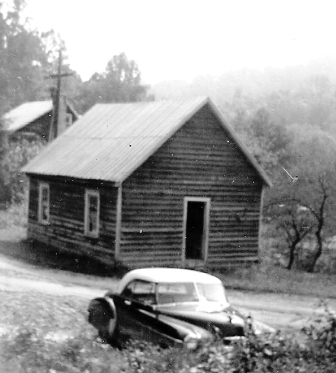
The Gallimore School, sometimes spelled as Galimore, was located near the Big Hungry River on what is today Gallimore Road. See photo below:
The Sunset View School operated until 1934. This school was located in today’s Green River Game Lands owned by the N.C. Wildlife Resources Commission. It was near Pulliam Creek and the Big Hungry River. The school was actually within what became Polk County, but there was no access to this school or community from Polk County. Students who attended this school consolidated into Dana School in 1934. Students who attended the school lived in both Henderson and Polk counties.
There was also the Upward School closer to Upward Road and the “heart” of the community. According to the late educator Ernest Justus, author Lenoir Ray, early deeds and statements by several individuals, the school was located at today’s corner of Howard Gap Loop Road and Crest Road. The school was located on land owned by the Justus family. It appears that at some time prior to 1932 it may have been located at the site of today’s Upward United Methodist Church, as church members purchased this property from the Henderson County Board of Education.
Students who live in the Upward community today attend Upward Elementary School and Dana Elementary School, Flat Rock Middle School and East Henderson High School.
Churches
The earliest church established in the Upward community is today’s Upward United Methodist Church.
Methodist circuit riding ministers came to the community early in the 1800s and services were held outdoors or in individual homes.
In 1848, Robert Jones and John Justus Jr. gave land at the “crossroads” for a church. Residents built a log building called the “meeting house.” The building was used by Methodists, Episcopalians and Dunkards.
Trustees of the property were Andrew Justus and Jonathan Tabor.
By 1898, the Dunkard congregation had left the community, and the Episcopalians will build a church.
The Methodists then sold the log building and property and bought property across the street, where the Upward Grocery once stood. The church occupied this building until 1932 when property was purchased at the current location on Upward Road. In 1951, a brick church was built. Members of the church were the Jones, Justus, Stepp, Hyder, Cagle, Pace and Blackwell families.
In 1898 Episcopalians were worshiping at possibly the log church or another wooden church at the “crossroads.” In 1907, Episcopal services were discontinued at the Gethsemane in the Big Willow community as most of the families in the area had moved. In 1923, this building was dismantled, taken to Upward and re-built. It was then named St. John’s Episcopal Mission Church, also known as St. John the Baptist. The building and land were sold in 1972.
The Upward Community Club was organized in 1953. The club has a community building and a ball field.
The Upward community is served by the Blue Ridge Fire and Rescue Department in East Flat Rock.